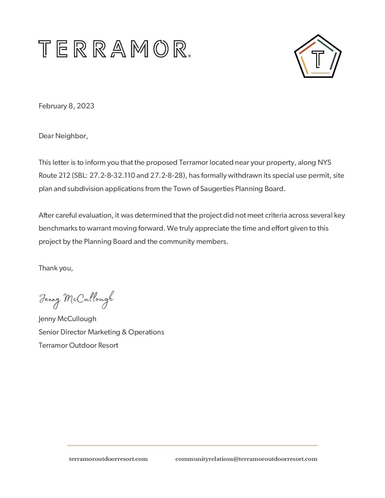
Wednesday February 8, 2023 – Terramor WITHDRAW their application


From the Saugerties Planning Board Secretary:

Please be advised that Terramor Catskills has withdrawn their application for the site located on Route 212 and Cottontail Lane.

We then fired off a very quick email saying:

Ms. Bertorelli, Mr. Post,
Thanks for the update.
People subscribed to the southpeaknabe.com site will want to know what this means.
Questions like:

  • * Have Terramor withdrawn the application so that they can work on it further and resubmit later? Answer from Terramor: No. The application is withdrawn with no intention to resubmit at a later date.
  • * If yes, does the entire process start from scratch (EAF, agency consultations etc.), or can they pick up from where they left off?
  • * If they are withdrawing completely and not planning a different submission, what are their options? Sell? Conservation Easement by limiting the deed? Answer from Terramor: We discussing our options internally.
  • * Can we safely assume that this is materially different from them asking for extensions, as other developers often do?
  • *Was any explanation offered (formally or not)? Answer from Teramor: As noted in the attached, after careful evaluation, we determined the property did not meet our criteria across several key benchmarks, including increasingly high costs of development in the market which impacted performance metrics.

Any and all insight the Board can offer will be appreciated by the many people following this project.

I will soon submit a FOIL for the withdrawal letter.

Thanks for your efforts.
Regards

And the Planning Board Chair wrote back:

We have no idea what they are thinking other than this application has been withdrawn and if they resubmit it will be from scratch . Nothing to stop them from re submitting .
They might sell… they gave no indication nor do they have to.
Howard Post

Here is the letter sent to neighbours:
Terramor Catskills Withdrawal

and as a jpg

This post will be updated with further details if and when they become available.


Sunday December 11th 2pm Informational meeting moved to Zoom

Apologies for the last minute notice.
Due to the inclement weather, the meeting scheduled for Saint Gregory’s church is moved to zoom.
Here is the link:
https://l.facebook.com/l.php?u=https%3A%2F%2Fus02web.zoom.us%2Fj%2F87487675805%3Fpwd%3DL1E1bmhENDNFY2l6N0pQZFhBZVJqZz09%26fbclid%3DIwAR0yuatGcZ-rRtjxCrR7RgnNAi9hAt32L5XtNd3A9E7rgqYjawimpYzmnnw&h=AT0FceOXN34DMcVoXaPBjrJH6q8kfm4Y0cucf31FHUNJq6hoql2R04LI8pOTgHs-8aksP-xEYyPlOJTf3tsuuqWVXID_zu6FC_3OV_GCvfF09yOzuQ7qwbv4C7ecs70p&__tn__=-UK-R&c[0]=AT1XST63XfZw-haODtlSuttQsNnZxQveJ01RM213jYkr1GWI4VhK_UhGCYqcMKEpxDGYbDi23rOOPjqp2JuIkQxMtS3BDDR5sRLBAE2Ir503WkjskK2sEcCszCsVZUCU2vuQgCAyZocDgNBY42aOWCx5ohsDc_3_xYY-7js

Terramor Catskills Saugerties Glamping Project added to Tuesday December 20th 2022 Saugerties Planning Board Meeting

The Terramor Catskills Saugerties Glamping Project has been added to the agenda for the Tuesday December 20th, 2022 meeting of the Saugerties Planning Board. The meeting starts at 7:30pm and is in the Senior Center next to Cantine Field (map below).

NOTE: While members of the public are encouraged to attend, this is NOT a Public Hearing (that will come later). BUT, it is important that there are bodies in the room.

Terramor is the second item in the “Old Business” section of the meeting. This comes after two Public Hearings for Minor Subdivisions. Public Hearings sometimes take a while and sometimes they fly by, so estimating a time when Terramor might come up is difficult. Safe to say, come well nourished and hydrated.

2022-12-09-Saugerties-Planning -Board-Agenda-for-December-20-2022

Find a map to the Saugerties Senior Center, 207 Market St. (next to Cantine field) here.

Citizens Against Terramor Public Meeting – Sunday December 11th – 2pm

Citizens Against Terramor Public Meeting Sunday December 11 2022 - 2pm - Saint Gregory's Church Rt 212 Woodstock

Citizens Against Terramor will hold a public meeting at Saint Gregory’s Church on Sunday December 11th, 20022 from 2pm to 3pm

  • Meet members of the board of Citizens Against Terramor sharing details of our recent hydrology / well testing report and analysis of the developers’ traffic report
  • Hear from folks like you who are concerned about the proposed glamping development in our neighborhood
  • Learn about the current progress of the Terramor application and the problems it raises
  • Learn about the Saugerties Planning Board process
  • Ask questions
  • Learn how you can help

All are welcome, no RSVP is needed.

Terramor Catskills Saugerties project makes Daily Freeman and WAMC

On Wednesday October 19th 2022, the Daily Freeman of Kingston NY published an article by William J. Kemble entitled “Woodstock residents see conflict over Saugerties glamping plan”. The article is embedded below. A short commentary follows. The text is also below.

The following morning, Thursday October 20th 2022, the editor of the Daily Freeman, Ivan Lajara, appeared on WAMC as part of the Morning Headlines series. The article about Terramor was among the items discussed. Click the link to hear the three minute piece.

Here is a .pdf of the article from October 19th
2022-10-19-Daily-Freeman-Woodstock-residents-see-conflict-over-Saugerties-glamping-plan

Commentary
While we understand that dramatic language yields column inches,*  language like “WW III” and “hardball” are hardly applicable here. In fact, the KOA/Terramor developers have been rather more open and collaborative than previous developers of this land. For example, the article was published just a couple of days after Terramor started testing neighbor’s wells during their own draw-down tests. As we pointed out in that post, these neighborhood tests are not required by law.

Further, KOA/Terramor have not yet really had a chance to play hardball. They are going through the expected process required by the Town, County, and State. That is a long process and there will be plenty of more opportunities for them to play hardball. We fully expect them to do so when it comes time to do the full SEQR process, for instance. That is their job. It is we citizens’ job to see that the Town Planning Board does its job overseeing the process and holding developers to account for every dotted “I” and crossed “T”.

Any reader of this site will know that we are no apologists for the developers, but it’s important that we keep a realistic and clear-eyed perspective on this process.


* We understand that reporting is a difficult business and that quotes are occasionally misheard, taken out of context, or mis-represented. We are assuming that the reporting and writing of this Daily Freeman article is accurate.


In case the .pdf does not display, here is the text of the article:

— article starts —

Woodstock residents see conflict over Saugerties glamping plan – Daily Freeman
William J. Kemble – Daily Freeman, Kingston NY – October 19, 2022 at 6:39 p.m.

WOODSTOCK, N.Y. — Residents with the Citizens Against Terramor group are forecasting a conflict against Saugerties if a proposed 75-site high-end camping, or glamping, project is allowed to proceed on 77.15 acres off of state Route 212 along the town line.

Group representative Paul Thurman following a Woodstock Town Board meeting Tuesday said there is a low sense of optimism that either Woodstock or Saugerties town officials will take concerns about the proposed Terramor development seriously.

“We’re afraid we’re headed for World War III because we’ve got a lovely caretaker government and these (developers) are playing hardball,” he said. “They’re going to walk right over use and are going to affect the quality of life in this community forever.”

Thurman, who noted that he spent eight years as a Buddhist monk, said the level of concern among the business community and residents has risen tremendously because of plans that include a 4,000-square-foot restaurant and events center, 28-person staff dormitory, an Olympic-sized swimming pool, a community fire pit, wellness center, maintenance building and a dog park.

“I hate conflict but the people who are coming at us are not nice people,” he said.

During the past year, residents have complained to Saugerties Town Board members about the need to reduce speeds along state Route 212.

However, Woodstock resident Richard Buck noted that the estimated 25,000 vehicles arriving over a seven-month period is a looming nightmare for existing community centers such as the Woodstock Jewish Congregation and the Woodstock Day School. In materials provided to the board, he noted the accident rate at the intersection of Glasco Turnpike and state Route 212 is “already five times” the state average.

“This is going ravage the community,” he said. “I know that Woodstock (town officials are) reluctant to get involved because this is a Saugerties problem,” Buck said. “But this is not a Saugerties problem. This is a Woodstock problem … this just does not belong here.”

However, in minutes from the July 19 Saugerties Planning Board meeting, officials wrote that they considered the traffic impacts to be low. “On average the proposed use would generate 17 (morning) trips and 22 (afternoon/evening) trips,” they wrote. There is a 100 trip threshold for requiring a traffic study. There was too insignificant of a change in traffic impact to require any changes (in the plan).”

In the Saugerties town material, Terramor officials said that the site would primarily be used between May and October, follow national Dark Sky guidelines to minimize light emissions, have a “strict noise” policy for “quiet hours beginning at 10 p.m., and would have about 25% of guests use fire pits that come with the camping sites.

Saugerties Supervisor Fred Costello said that comments from Woodstock residents would have the weight of Saugerties residents’ comments because the impacts would be a shared burden.

“I think the Planning Board will consider the concerns equally,” he said.

“I don’t believe there’s a need for them to be aggressive,” Costello said. “I think if they make the case for whatever concerns they may have, I’m confident our Planning Board will weigh those concerns equally and as considerately as those concerns on the Saugerties side. We certainly don’t want to be a bad neighbor.”

— article ends —

Well testing starts on Terramor property and surrounding neighbors – Plus catch-up on other matters


On Monday October 17th, Terramor started testing the first of three proposed wells on their site. They also started testing 4 or 5 wells on surrounding properties. Tests had originally been scheduled for 24 hours, but after input from a hydrologist (whose letter you can see below), the time span was expanded to 72 hours.

Terramor’s testing of neighbor wells is not required by any regulation of the state, Ulster County, or the Town of Saugerties. Results from these test will be shared with the NYSDOH, the Town, and the neighbors. Tests are done to find out in what ways the pumping of the Terramor wells might affect nearby wells. The technology used is “sonic water level meter” and readings are to be taken every two hours. As the hydrologist’s letter points out, this form of testing is sub-optimal. Thus, several neighbor well will also be monitored using a more precise transducer system, and readings take every five minutes. It is possible that the Planning Board ot the DOH may require further testing later.

Here is the copy of the letter sent by the hydrologist to KOA/Terramor and the Planning Board:
2022-10-04-Hydrologist-Letter-Terramor-Aquifer-Test-Recommendations

If you cannot see the embed above, here is a .pdf of the letter: 2022-10-04-Hydrologist-Letter-Terramor-Aquifer-Test-Recommendations


A note about one particular claim from the developers’ response to NPV comments – With history and links
This letter was sent to the Planning Board on September 29th 2022. It lays out the shortcomings of one particular part of Terramor’s response to the Planning Board’s consultant’s (NPV) comments on the initial submission.

— letter starts —
September 29 2022

For distribution to the Public file and members of the Saugerties Planning Board

Members of the Planning Board,
I write with a note about one specific paragraph in the LA Group/Terramor August 1st response to NPV’s July 11th comments.
https://drive.google.com/file/d/1gttGf_uZuZyJn55QLDcL2RiI8IKfJ3eT/view?usp=sharing (OR: https://bit.ly/Terramor-response-to-NPV)

As part of the developers’ August 1st response to NPV comments they write:

(NPV comment bottom of page 4)

f. (s) Nuisances. The proposed use shall not be more objectionable to nearby property owners or occupants by reason of noise, fumes, vibration or lighting than would be the operations of a permitted use.

[snip]
LA Group/Terramor response top of page 5:

With the provision of central water and sewer like the proposed facility, giving consideration to development constraints posed by the presence of wetlands and steeper slopes on the property, and considering that the original proposal for the South Peak subdivision on the property contained 43 single family homes, the Applicant estimates that the site appears capable of supporting approximately 50-60 single family homes. Each of these homes would have their own associated noise, fumes, vibration and lighting.

This paragraph is both artfully worded and elides historical facts:

1)The South Peak project was originally proposed as 41 lots (August 2004) – https://drive.google.com/file/d/1KLAkTYyd6_A09JoEB95BzSdtLLxd-txY/view?usp=sharing (OR https://bit.ly/South-Peak-original-41-lot-drawing)

2) The Conditional Final grant was for 23 lots (April 2007) https://drive.google.com/file/d/10g0QTKxRClLANjOgrLOZYZFFNOPlNwww/view?usp=sharing (OR https://bit.ly/South-Peak-Conditional-Final)

3) And the final design was for 22 lots (May 2011) https://drive.google.com/file/d/1K0qq-gmrzf4nIUBJ39V4592XzhBQvOJm/view?usp=sharing (OR https://bit.ly/South-Peak-UCDH-22-lots)

During this years-long process the Board repeatedly noted the extreme difficulty of the land, the UCDH granted permits for 18 septics (later increased to 22 by dint of redrawing lot lines), and there were countless other revisions along the way.

To now claim that “the site appears capable of supporting approximately 50-60 single family homes” is preposterous. I can imagine the Board laughing harder at this claim than they did when first Mr. Rothe proposed 41 lots back in 2004. Building techniques may well have improved, but not that much. Indeed, our standards for roads, wells, septics and the like have probably gotten tighter over the years, making the 50 to 60 figure even sillier.

While I am confident that members of the Board with long memories will have picked up on the ridiculousness of this particular LA Group/Terramor claim, I wanted to bring special attention to it. Board members will have to decide for themselves to what extent this puffery speaks to the credibility of other LA Group/Terramor responses to the NPV comments.

Thanks for your efforts and for your time.

Regards

Mark Pisani
— letter ends —
Here is a .pdf of the letter: A note about one particular claim from the developers’ response to NPV comments – With history and links


There were no other submissions in the public file as of October 17th, 2022. Terramor did not come up at the October 18th Planning Board meeting.


Added a simple page to the site with instructions on how to write a letter about the Terramor Catskills Development.

Well-testing proceeds on Terramor property

Well water testing

Immediate neighbors of the Terramor property will notice increased activity on the property over the next couple of weeks.

As announced a while back, contractors for the developer will be testing three wells. Tests should start Friday September 16th and continue for up to three weeks. Neighbors may see heavy equipment moving and will hear generators.

There will be several steps to the testing:

  1. First, each well will undergo “step tests”. These tests may happen simultaneously at each of the three wells.

    A step-drawdown test (or step test) is a single-well pumping test designed to investigate the performance of a pumping well under controlled variable discharge conditions. In a step-drawdown test, the discharge rate in the pumping well is increased from an initially low constant rate through a sequence of pumping intervals (steps) of progressively higher constant rates. Each step is typically of equal duration, lasting from approximately 30 minutes to 2 hours. Each step should be of sufficient duration to allow dissipation of wellbore storage effects. (From http://www.aqtesolv.com/pumping-tests/step-drawdown-tests.htm

    Pressure in the well is also measured all during this process.

  2. Next, each well will be subjected to a “constant flow” test.

    A control well is pumped at a constant rate and water-level response (drawdown) is measured in one or more surrounding observation wells and optionally in the control well itself. The goal of a constant-rate pumping test is to estimate hydraulic properties of an aquifer system such as transmissivity, hydraulic conductivity and storativity (storage coefficient). (From http://www.aqtesolv.com/pumping-tests/constant-rate-pump-tests.htm)

    A constant flow test will last at least 24 hours, but should likely last longer than that to generate more accurate data.

  3. Finally, immediately after each of the constant flow tests at each individual well, samples of the water will be taken for analysis.

Readers may remember that Terramor has expressed a willingness to “test neighbor wells while we test ours”. We have contacted Terramor to find out about this and have been told that they are working on it (2022-09-24). At a minimum, it seems that these neighbor tests should include all wells withing 1000 feet of Terramor property lines, should include water quality sampling (for contaminants) and, most importantly, tests to see if neighbor wells react **during** Terramor’s constant flow tests. These tests would likely involve dropping a transducer down the neighbor’s well bore hole and taking pressure measurements at short, repeating intervals for the duration of the test. The most accurate data would be obtained by minimizing household water use for the duration of the test.

We will update this site as we get more details of how neighbors might participate in testing.

As always. please advise errors or omissions.

An email from Terramor and a few other notes – June 15th 2022

Here is the text of an email recently received by a number of Terramor neighbors. It was sent in the afternoon of Wednesday June 15th. Read on after the email text for a few more updates.


Dear Mark

First and foremost, thank you to everyone who joined us for our meeting and walk through of the property last week. We really appreciate your input and participation in these discussions. We are committed to continuing an open and honest dialogue with the neighborhood.

We understand there are concerns about the project as related to density, proximity to the neighbors, noise, traffic, wildlife, pesticides, water and sewage, and more. We are taking all of your feedback into consideration.

Density:
To clarify, we learned about the opportunity from the town to add additional sites just days prior to our last community meeting. Our decision to propose 75 units took many factors in to consideration; land management, adhering to our light-on-the land techniques, water usage, guest experience and infrastructure costs.

Rather than wait to submit the new conceptual layout with added sites to the Saugerties Town planning board, we made a conscious decision as a team to discuss this layout with you, our neighbors first. We understood that it would be a surprise to many of you, but wanted to be forthcoming so there were not any feelings of being misled when you saw the final design submitted to the town planning board. Because of this, we understand the surprise and frustration many of you felt during last week’s meeting. Our intent was, and still is, to be as open and honest with each of you during our planning process.

Proximity to Neighbors:
As a direct result of our walking the property, we are now looking at relocating a number of tents near neighbors on Raybrook to other areas of the resort.

Noise, Traffic, Wildlife, Pesticides, Water & Sewage:
We want to remind everyone that we have a very strict noise ordinance at Terramor. This will be followed at this property and is a condition of the special use permit. We are also currently working with traffic engineers to ensure the safest entry point and will complete additional studies per their direction.

While we have yet to identify pesticide or insect management for this particular property, we will work to find eco-friendly, safe solutions as an alternative to chemical management. Finally, we in the final stages of evaluating various systems with regards to water and sewer. We will have more information for everyone at our next meeting regarding water and sewer as the various systems are currently being evaluated.

Guests & Special Events:
Our resort caters to families and adults seeking to enjoy the outdoors, comfortably. A typical guest at Terramor will explore the area during the day and come back in the evening for a meal at the Lodge and to relax and unwind either by campfire, poolside or in the privacy of their tent. On average, a Terramor guest will spend $137/person a day in the local community during their visit. Terramor guests are individuals who simply want to get-away, enjoy nature and, in many cases introduce their families to the wonder of the outdoors.

We do plan to host limited weddings and retreats at this location. With that, special events will adhere to our noise ordinance and be required to stay on property to participate in the events. Eliminating the need for Terramor to have additional parking areas and lessening the traffic implications.

What’s Next:
We will be submitting a preliminary conceptual site plan and project details to the Town of Saugerties planning board for their July 19th meeting. The board will then provide technical feedback to us which may require additional work or studies on our end. All the information we submit will be public knowledge. Once the town planning board is satisfied, they will schedule a public hearing. At that time, they will make the decision regarding the special use permit.

We will be holding a third neighborhood meeting on Tuesday, July 26th to review our submitted site plan and project application. At this time, we will share any comments received from the planning board, answer any additional questions and hear your feedback.

Please check your emails soon for more information on this meeting.

Until then, please direct any questions or inquiries to Jenny McCullough at communityrelations@terramoroutdoorresort.com

Best,

Jenny McCullough
Director, Brand & Operations
Terramor Outdoor Resort


A few more points:
1) Before this email went out Jenny called me and we had a chat about the content. She said she would also be calling other neighbors. She asked for my assessment of the walkthrough. I directed her to the post before this one and gave her a quick précis. I emphasized the proximity to Raybrook and traffic issues. We spoke about Teramor seeking out a relationship with DOT to make the traffic issue top of mind there. Especially with regard to sight distances, speed limits and the Glasco/ 212 junction. She mentioned that they are conducting another traffic study and that this would be part of their submissions to the Board.

2) Today (Wednesday 15th) I stopped by the Town Hall and looked again at the Terramor public file. There was nothing new in it since last I visited and posted the documents seen here. I ran in to Kevin Brown, Assistant Building Inspector, and asked about the number of units. He confirmed that it was the his office which clarified the 50/75 units issue to Terramor. Our previous assumption that it was the County was incorrect and I apologize for the error. He was careful to point out that they merely told that developers that code could allow up to 75 tents/sites, but that the Planning Board would have final say over that number. He was also careful to state that the code was derived from rules about camping and RV establishments with transient occupancy. There was a very particular reason for this and I can share privately what that was. He also said that the dormitory for workers was allowed, and a lodge without residential units.

3) With regard to the timing of submissions from Terramor to the Planning Board: If they want to be before the Board July 19th, they have to submit all required paperwork by July 5th. We will do what we can to get those documents on to the site as quickly as possible. We’ll shoot for July 6th. The July 19th meeting will be public and, while we may not yet be able to comment in person, we encourage everyone to show up and listen carefully to the submission. This will be useful for the informal July 26th meeting with neighbors mentioned above in the email from Terramor.

Some takeaways from the June 7th Terramor presentation and site walk

Note: Observations below are my own and likely do not conform to everybody’s experience of the presentation and walk-through. Conversations were happening between neighbours and Terramor, the engineer, and the Board planning consultant. Different folks will have had different encounters and takeaways will vary

June 9, 2022

On June 7th several neighbors of Terramor and other interested parties gathered in the South Peak Vets parking lot, under gloomy and damp skies. A presentation was made by one member of the Terramor staff and one member of the land planners working on the project.

  • The first, and most disconcerting, point offered was that the project’s proposed scope has expanded from 50 tents to 75 tents. This was a result, we were told, of the “code enforcement office clarifying the number of units permitted on this land”. According to Terramor, the discrepancy was as a result of the earlier talks with code enforcement not precisely spelling out that the proposed “lodge” was not residential. Apparently, were the proposal for a residential lodge, code would have allowed 50 units, but given that the proposal is for tents separate from the lodge, code for this site will allow up to 75 tents. It was not apparent to me which code enforcement office this was, but I assume it was the County. (EDIT: It was the Town)
  • Reaction to this announcement was, predictably, one of surprise and anger. Many of the assembled company were alarmed that the deal had changed, and with no notice at all. The Terramor representative stressed that she had only found out about it a few days before and there was regret that such a substantial change had not be communicated earlier. As the questions came thick and fast, she tried to explain that the economics of the proposal were marginal at 50 tents and that 75 tents was more reasonable, given that code allowed it. Reaction to this assertion was skeptical, at best. A rambling discussion followed, touching on many of the familiar and salient areas of neighbourly concern, water, septic, pesticides, traffic, wildlife, etc. Tempers were somewhat frayed at times, with neighbours wondering if Terramor were, indeed, listening to local concerns.
  • The presentation continued with reference to the new sketch plan. Several other changes were noted. Primarily, the relocation of the worker’s dormitory. This was moved away from the previous location near the Cottontail emergency exit and further up the hill. It was suggested that more tents meant more staff and this was acknowledged, vaguely. A description was given of how the extra 25 tents were added to the site. The land planner stressed that the fifty foot distance between tents was still achieved and that the average was slightly higher than that.
  • There were many questions about the distance between the tents nearest the property line up by Raybrook. Discussion ensued about code for the buffer and the planned approach to the issue. It was resolved that the walk would affirmatively include a visit to that area so that we could see for ourselves. The claim was made that the nearest tent to the property line was 85 feet away.
  • The location of the entrance to the site appears to be nearer to the Woodstock side of the site than the last approved project, a decade ago. We were told that this location had been suggested by the Terramor traffic consultants, but that the land planner present was not expert in this area. The reason given for being as close to the Woodstock side as possible is that the project wishes to minimize ground and wetland disturbance. Please see a separate post here for more about the traffic issue: http://southpeaknabe.com/terramor-and-traffic/
  • Terramor acknowledged that they had not met the filing deadline for the June Planning Board meeting and said that they were hoping to file for the July meeting instead. Submission deadline is July 5th for the July 19th meeting
  • Some folks decided to leave and the walk commenced. While the choice may have been made for expediency’s sake (footwear etc.), it was instructive that they did not take us up from the proposed curb cut and over the (extensive) wetlands at the foot of the property. We walked up the significantly drier adjoining property (between the Vet and Terramor) and thence across to the proposed access road.
  • Terrain varied from swampy to firm-ish. “Map-checks” were made along the way, with the land planner indicating the route of the road and other proposed parts of the project. The “Welcome Center” was pointed out and it was again stressed that guests will park in one of several car parks but walk to their tents from there. Tents are generally not accessed directly from the paved through road. Paths to tents will be made of permeable material, including fabric, gravel and other engineered aggregates. Mention was made of the desire site tents so as to cut down a minimum of trees. Tents will be built on wooden platforms. “No, we do not propose concrete footings”.
  • Along the way, different conversations were held and comments made. I did not hear all of them. It was repeatedly stressed that this was all very much a work in progress and that engineering and planning details would change constantly as this difficult land presented new challenges.
  • Septic: Will be dealt with by pumping it from individual tents, likely to a central above-ground facility. This would probably be pumped at the end of the season. “We are still working on this”
  • Well-water: Thinking is that there will be three or four wells. Possibly feeding an above ground tank and distributed to tents via underground piping. Wells appear to be 200 to 300+ feet deep. So far, they propose to use the test wells currently on site. System might be blown out during the winter so that there is no water in it to freeze. Especially since trenches might be shallow enough to be frozen. “We are still working on this”
  • Water run-off: Road will be tilted, with swales at the sides. run-off will likle be fed in to the existing wetlands. There are currently no plans for added ponds. (This means that mosquito suppression via aeration of standing water is not possible. They are not adding standing water to the site and they cannot add aeration to existing wetlands)
  • Electric: to individual tents via trenches.
  • When we arrived at the top end of the site, furthest from Rt. 212 and nearest Raybrook, I volunteered to stand on the exact spot of the tent nearest the property line. The groups was then able to see the geography more plainly. From my vantage point I could see two houses, though not clearly. It was clear that they were there, but features were indistinct at best. I could see marker flags indicating garden beds and, possibly, the property line. Foliage was somewhat dense, given the time of year, but a proper screening hedge will certainly be necessary. A discussion ensued as to how to keep guests from wandering out of the property and into neighbour’s yards. It was apparent that Terramor will have to instruct guests very firmly, carefully, and repeatedly about not going where they should not. It was agreed that at least one tent had to be moved away from the property line.
  • There was some confusion about the Planning Board protocols. The representative of the Town consultants gave a concise explanation of the differences between the Planning Board meetings and the Public Hearing. Basically, the first formal Planning Board meeting allows the project to be presented and starts an ongoing process of information gathering, technical and otherwise, by the Board. This ongoing process also allows for input from the public and any other outside interested parties. Later in the process, the Board may schedule a Public Hearing, at which all are welcome to comment.

    Here are two further short explanations:

    From the consultant who walked around with us:

    Experts are directly hired by the Planning Board to review a project if the Board feels it is necessary. For example, the Board will hire its own traffic engineer to review and comment on the applicant’s traffic report and so forth. The Board relies on these hired experts, and comments from involved agencies such as NYS DEC and DOT, to identify glaring issues, permit requirements, or items that would need to be addressed for an approvable project. The Town Code and NYS Environmental Quality Review Act provides a framework for this investigation.

    The public can also provide comments from their own expert, and present those comments during public hearings.

    Formal meetings are the only time that the Planning Board can discuss the project as a quorum without violating NYS Open Meetings Law, so allowing the technical review to proceed month by month at these meetings is important to the Board’s decision making process.

    From the Planning board Secretary:

    The Planning Board’s procedure is to allow anyone to speak from the public with concerns/comments only at the meeting in which a public hearing is open. If the Planning Board has an expert that they have hired for review/advice then they may invite that person/persons to speak at a given meeting. Anyone is welcome to send in a letter addressing their concerns at any time during the process for the Planning Board to review and take into consideration. The first meeting is generally to familiarize the Planning Board with the project and let the Town Planner and Planning Board members address initial concerns or suggestions. A public hearing will only be scheduled when the site plan is complete enough, which is determined by the Planning Board with the Town Planner’s guidance. A public hearing can be kept open, with the Planning Board’s approval, if concerns are raised by the public that need to be addressed with an updated site plan or additional information.

  • As the walk wound down and we arrived back at the Vet’s, the Terramor representative suggested that there be more informal meetings. Probably in the time after their formal submission to the Board and before their formal appearance. At the moment, they hope to meet the July 5th submission deadline for the July 19th meeting.

Comments are open and tightly moderated.

Note: I have certainly forgotten some parts of the afternoon and some specifics. Your input is appreciated. You can comment publicly, or contact me with corrections and additions

WhatsApp Group added


In an effort to expand ways to stay informed, we have added a WhatsApp Group. You can join it here. There is also a link in the sidebar of the site.

This should be a low volume, tightly moderated group, mainly focused on distributing news about the development, including formal submissions to the Town, public meetings, FOIA results and the like. There will also be links to the posts on this site. While we welcome discussions about the nature and fact of the Terramor development, off-topic discussions, ramblings, etc. are particularly discouraged.

Please get in touch if you need help signing up to the Whatsapp Group.

January 7 2022 – KOA has officially acquired the land

According to records at the Ulster County Clerk, KOA has now completed transfer of the deed to the land in question. The price was $950,000.
Here are some very rough screen grabs of the deed transfer document. Click on each for a slightly larger version. You can find better resolutions by making your own search on the Ulster County Clerk’s Land Records IQS page (https://www.searchiqs.com/NYULS/SearchAdvancedMP.aspx) and using the search term “Saugerties Developers LLC”

Terramor deed transfer


Terramor deed transfer

November 23, 2021 – Introductory Letter from KOA/Terramor

Immediate neighbours (we assume those who have property contiguous with the South Peak properties) have received a letter, dated November 15th, from Jenny McCullough, Director of Marketing & Brand Experience, Terramor Outdoor Resort. The letter was drafted November 8th and was adjusted after some written and spoken input from at least one neighbour.

Below is the text of the letter. You can also download the .pdf here: http://southpeaknabe.com/wp-content/uploads/2021/11/Teramor-Saugerties-Introductory-Letter-final-as-sent-11-15-2021.pdf

This site solicits your comments and reactions. Please also send suggestions for follow-up questions for KOA/Terramor. If you send a question to KOA yourself, please tell us about it and tell us about any response you get. Information sharing and transparency will help everyone in the long run. Site admin for SouthPeakNabe.com can be reached at: mark@southpeaknabe.com
OR
845 418 6947 (wait for screening message)

Once again, we stress that this website, SouthPeakNabe.com, has no association with either KOA or Terramor or the Saugerties Planning Board. It is merely an informational website attempting to keep neighbours and other interested parties up to date on developments in and around the South Peak area of West Saugerties.

——————–

Full text of letter sent to neighbours:


November 15, 2021
Sent On Behalf of Terramor Outdoor Resort
An entity of Kampgrounds of America, Inc.
Jenny McCullough

Dear Neighbor,
We want to take this opportunity to introduce ourselves to you and help answer any questions or concerns you may have while we are in the process of purchasing the 75.12 acre of land located within your neighborhood on Route 212.

We are Kampgrounds of America, Inc., known mainly as KOA. Historically, KOA is the largest camping brand in the world, with over 500 campgrounds across North America. While our KOA campgrounds service RVers, tent campers, motorhomes and more, the intent for this property is to expand our new venture focused on introducing individuals to the great outdoors in an elevated and comfortable way.

In 2020, KOA launched a new brand called Terramor Outdoor Resorts in Bar Harbor, Maine. Terramor, which means “love of land,” is a new concept with custom made canvas and hard-sided tent accommodations. Our Terramor properties include:
* Central Lodge with a small kitchen, concierge desk and check-in
* Heated outdoor pool and hot tub
* Communal pavilion for onsite activities
* Nature trails throughout the property
* Designated parking areas, encouraging our guests to walk to their accommodations and around our campus
* Canvas and hard-sided tents, located a minimum of 50-feet form one another
* Privacy and noise-scaping to help prevent noise both on and offsite

We take our ‘love of land’ name seriously. Our properties are designed to have limited impacts on the land; utilizing one or two central septic systems, creating unpaved roadways, participating in recycling programs and more. All of our tents are built on elevated platforms to minimize destruction to the land and are pushed back into the forests to provide privacy. In our flagship location, we replanted over 1,000 trees to the property and worked with the Acadia National Park’s landscape architect to use local flora and fauna and rebuild the natural ecosystem for our guests to enjoy.

The property in reference is zoned for a campground with up to 50 sites. While we do not close on the property until late December, we anticipate this site to have 50 tent accommodations. Our design plan is to build the luxury campground off of Route 212, tucked into the acreage so it would not be visible from the road. While we will have an access road on Cottontail, this road would not be a main entrance and serve more for emergency vehicles. Terramor Catskills would operate on a seasonal basis for 7-9 months a year.

We are committed to being a high integrity, respectful and quiet neighbor. We institute a strict quiet hours policy at our property to ensure our guests get to experience the sounds of nature. Terramor’s brand exemplifies both the love of land and love of locale, which means we work hard to be a strong community partner. We work to source much of our food and beverage locally, sell locally made products and gifts in our store, promote local businesses, guides and tour operators and help educate guests on the importance of outdoor conservation.

We are currently working with the city and county to ensure required and recommended studies, procedures and licensing is taking place. In the meantime, please take a moment to get to know us a bit more by visiting our website, www.terramoroutdoorresort.com.
If you have any further questions, you are welcome to send me an email at communityrelations@terramoroutdoorresort.com. We look forward to becoming a member of your community!

Sincerely,

Jenny McCullough
Director of Marketing & Brand Experience
Terramor Outdoor Resort
406.670.7511
— ends —

——————–

November 04, 2021 – Very short update

A busy couple of days. A few updates:

  • Neighbors from the Raybrook development have been in touch. They also raise concerns and will be part of the process.
  • KOA/Terramor confirm that they have not formally acquired the land.
  • Because of that, they cancelled/postponed the preliminary and informational Zoom call they had scheduled. I wrote them and expressed disappointment. There may be informal follow-up there.
  • Saugerties Planning Board confirms once again that there is no formal application or any other paperwork in front of the Board.
  • Still working on questions to be raised with developers and Board. Please advise your own.

South Peak – A Different Tack – First Activity in Years – November 2021

KOA Terramor South Peak Saugerties Proposal

KOA Terramor South Peak Saugerties Proposal

November 01, 2021

Neighbors of the South Peak Saugerties property may have noticed activity on the hill over the  last few weeks. This is the result of a early-stage proposal for new development on the property.

While there has been no formal application to the Town, and it is very early in the process, we do know a few details:

  1. The “Terramor” division of KOA is exploring siting a glamping operation on the site.
  2. Surveyors have spent at least three days on the site. They were re-surveying the site to see if anything had changed since the last survey undertaken in 2003/2005. This is often a due-diligence requirement before properties formally change hands.
  3. The well drilling folks  were on the property to clear paths to the old test wells on the property. We do not know if any testing has yet taken place.
  4. As far as we can tell, the Ulster County Clerk has not yet recorded a formal sale of the two lots. They appear to still be in the hands of the most recent owners of record.
  5. While there has been no formal proposal to the Town, the KOA people have attended at least one informal Planning Board workshop. This is usually an informal opportunity for developers to understand the Town’s planning process and to ask the Board preliminary questions about the proposal/approval workflow.
  6. An initial outreach to the KOA folks yielded a relatively positive response, including an invitation to join the Director of Acquisitions and the Marketing Director at KOA/Terramore for a Zoom call with members of the Planning Board.

We are formulating a series of questions for the new developers and the Planning Board. Not surprisingly, these revolve around the same concerns expressed years ago when the proposed sub-division was under discussion and achieved conditional final approval.

It’s important to note that this is a very different proposal (“special use” vs. “subdivision”) and so some efforts required of the developers will be different. Additionally, some very particular facts about the immediate neighbourhood have changed and these changes affect certain parts of the Planning Board’s considerations.

Site admin for SouthPeakNabe.com can be reached at:
mark@southpeaknabe.com
OR
845 418 6947 (wait for screening message)

We welcome any constructive input and, especially, questions and concerns which can be raised with the developers and Planning Board.

It should go without saying that this website, SouthPeakNabe.com, has no association with either KOA or Terramor  or the Saugerties Planning Board. It is merely an informational website attempting to keep neighbours and other interested parties up to date on developments in and around  the South Peak area of West Saugerties.

A word with the developer (EDIT: And minutes from Saugerties June 2011 Planning Board Meeting

Thursday June 16 I had a chance to chat with Bill Kugelman of Philips International. He is the man in charge of the South Peak Subdivision for the developers.

Points he made:
* There is no firm start date or breaking ground date. He was very careful to emphasize that in the current market it would not be prudent to commit to a particular date.
* When asked what the order of developments might be, Mr. Kugelman said that this was an aspect of the development which was still under discussion. He said that obviously it would be better to have sold plots and locked in buyers before building the road, because nobody want anyone to build a road to nowhere. But he was not confident that that pre-sales would be forthcoming in the current climate.
* The developers remain committed to the project.
* Mr. Kugelman was at pains to point out the developers’ commitment to the off site drainage projects on Osnas and Cottontail.
* He will not be at the June 21 Planning Board meeting. The engineer and the developer’s lawyer will be.

EDIT (Aug 25, 2022 – adding minutes)
The June 21, 2011 meeting took place. Minutes here

OLD BUSINESS:
1. Major-South Peak / Philips International-Rt. 212-Plans presented by Nancy Clark, Engineer- In 2007 proposed 23 lots and have Conditional approval. Now 22 lots and here to propose Phasing. They are working on Health Dept. approval for all lots.
Phase 1 – will be 4 lots off Rt. 212, new road to cul-de-sac, and drainage improvements on Osnas Lane.
Phase 2 – including Cottontail Road with 4 lots and stormwater drainage.
Phase 3 – including the rest of the lots.
Clark-meetings with Mark Pisani (Osnas Lane representative) have gone well. The Engineering for the whole project is done and Pl. Bd. will approve each Phasing on separate maps when submitted to the Pl. Bd. The time limit is 3 years. Discussed Stormwater District. Mark Pisani-pleased with Pl.Bd. and Engineers workings with him.

A motion by Goldberg, seconded by Weeks to approve the Phasing of this project and now approve Phase 1 with all Conditions. All in favor, none opposed, carried.
Clark-with reference to Conditions-this does not need nor ever did need to be sent to Ul.Co.Pl.Bd. under the rules at that time and Cultural Research has been done as these Conditions are old.
Clark-On August 18, 2011 extension expires. A motion by Creen, seconded by Weeks to grant a 90 day extension from August 18, 2011. All in favor, none opposed, carried.

This is the point at which they settled on 22 houses (down from the 41 they started with in 2004).
— End Edit –

South Peak Subdivision Development Maps

South Peak Subdivision Development Map
This map shows the outline of the land to be occupied by the South Peak Subdivision Development. Click map for full size image.

South Peak Subdivision Development Phase 1
This map shows the outline of work to be done in Phase 1. Click map for full size image.
Light green line will be town road. Blue line is limit of land to be worked on. Light blue circles show the location of houses. Brown lines are driveways.

South Peak Subdivision Development Phase 2
This map shows the outline of work to be done in Phase 2. Click map for full size image.
Light green line will be town road. Blue line is limit of land to be worked on. Light blue circles show the location of houses. Brown lines are driveways.

Phase 3 links the two roads and adds 14 plots.

This is a *very* rough approximation of the actual plans. I am not a draftsman!

South Peak Subdivision Development: Unanswered Question

Now that the contours of the phased development plan are known, there are a few questions to which we do not yet have the answers:

In what order does the development proceed now?
That is, do the developers sell plots, achieve a certain level of sales and then build the road for Phase One? Or do they get started building Phase One and hope to sell plots as they go along?

Are they confident of any particular velocity of sales? Or are they only confident of selling a few plots to start with and proceeding from there?

As soon as answers become apparent we’ll post them on the site.

Developers’ Engineers June 7 2011 Letter to the Planning Board summarizing the latest submissions

In this letter the Engineers conveyed the latest revised plans to the Board. The revisions encompassed changed asked for by the Board at the March meeting. The letter also summarizes activity and filing since the March 2011 meeting.

The letter was accompanied by full sized plans which are too large to be reproduced online.

First page of the letter:
Engineers June 7 2011 Summarizing Letter to Planning Board Page 1 of 2

Second page of the letter:
Engineers June 7 2011 Summarizing Letter to Planning Board Page 2 of 2

Letters regarding drainage, NYSDOT and SWPPP

South Peak Developers’ Engineers Letter to NYSDOT 05-10-11 South Peak Drainage Re NYS Route 212 (pdf)

Attached to this letter in the Public File are:
1) A letter dated August 16 2007 to Dewkett Engineering from NYSDOT approving submitted site plans dated May 14 and August 15 2007.

2) A letter dated September 8 2010 from Ulster County DPW to Erdman Anthony Engineers saying that the August 2 2010 revisions to the SWPPP appear to conform. The letter is reproduced here: UCDPW Sept 8 2010 Letter to EA Re SWPPP (pdf)

3) The March 24 letter from the Town engineers, Brinnier & Larios, to the Planning Board saying that the October 22 revisions to the SWPPP satisfy local and state requirements.

The new developers and engineers

Developers:
William Kugelman
Saugerties Developers LLC c/o Philips International
295 Madison Ave., 2nd Floor
New York, NY 10017

P 212-951-3838
info@pihc.com
http://www.pihc.com/

In late 2009 the original developers “212 Developers” sold up and the development was taken over by Saugerties Developers LLC / Philips International

Engineers:
Nancy Clark
Erdman Anthony
530 Enterprise Drive
Kingston NY 12401

P 845-383-3661
clarkn@erdmananthony.com
http://www.erdmananthony.com/

Erdman Anthony bought out the original engineers, Dewkett. The approved plans were carried over to the new firm and have been adjusted along the way to conform to new DEP regulations and the phased development proposal.

March 2011 – Phased development proposed

As of this writing (June 14, 2011) the minutes from the March 2011 meeting are not yet posted. So the items below are as related to me by various people who were at the meeting.

The new developers said that they wanted to move to a phased development schedule. They proposed a proposed a three-phase schedule. Off-site drainage improvements were to handled during the last phase of construction.

The Planning Board said that the Osnas Lane drainage improvements should be moved to phase one. To help this along, the Board allowed for one more house to be added to Phase One (if the developer wanted it). It was suggested that the new engineers visit the Osnas Lane area to check the conditions in the field.

The roads in Phase One and Two were to be terminated in temporary cul-de-sac turning circles, to Town code.

There was discussion of the easements required for work on Osnas Lane. It was decided that the Town would seek easements from affected property owners so that the work could be done. Apparently it was not known that there is already a 10 foot Town easement for the affected areas. A 20 foot easement will be sought. (I think that it is likely that the easement will revert to 10 feet once the work is completed.)

When the minutes for the meeting are posted I will link to them.

Saugerties Town Planning Board Minutes June 15 2010

Saugerties Town Planning Board Minutes June 15 2010 (pdf)

South Peak / Rt. 212 Development –Plans presented by Nancy Clark – Pl Bd gave
Conditional final approval to 23 lots and DEC approved 18 lots. DEC changed
regulations and applicant received credit for infiltration. They reduced pond sizes and
can now add 4 lots that were lost from DEC – Lots 13, 14, 18 and 20. No other changes
to Conditions. Applicant asking for another 6 month extension-present extension expires
in Aug. 2010 so this extension would expire in Feb. 2011 as the Health Dept. is
reviewing the new plans. A motion by Creen, seconded by Goldberg to extend
Conditional Final approval until Feb. 2011. All in favor, none opposed, carried. Creen they started with 26 lots, now 22 lots so subdivision has gotten smaller

Saugerties Town Planning Boad Minutes January 19 2010

Saugerties Town Planning Boad Minutes January 19 2010 (pdf)

Major-Route 212 Developers/South Peak NOW Saugerties Developers LLC-want an
extension with all prior Conditional Finals since acquired by another entity. Wayne
Graff, Esq., William Kugelman of Philips International and Nancy Clark of Erdman
Anthony present. Two test wells need approvals and subdividing into 23 lots so need
Health Dept. approvals. A motion by Creen, seconded by Furman to grant a one-year
extension. All in favor, none opposed, carried. Attorney Graff- thank you-would like to
get this moving within the year. Creen- rescind prior motion. A motion by Creen,
seconded by Weeks to grant a six (6) month extension. All in favor, none opposed,
carried.

Saugerties Town Planning Board Minutes April 17 2007

Saugerties Town Planning Board Minutes April 17 2007 (pdf)

Minor-Rt. 212 Developers / South Peak-Rt. 212-Maps presented by Robert Capowski Status-DOT still under review. DEC still in review-stream disturbance. Army Corps was submitted for flagging. Town Eng. Reviewing drainage for Osnas Lane and structure on Cottontail Rd. Will put in 24in. pipes for Osnas Lane and improved drainage. Cottontail Rd.-road topped-asphalt overlay and updating pipe. Discussed letter to Planning Bd. dated April 17, 2007 from Dewkett (did not receive yet). Wetlands have been flagged and need Corps to approve. Will comply with Ulster Co. Pl. Bd. comments. Lot 13 has been eliminated. Mark Pisani-speaking for neighbors – all concerns seem to be answered except for Cohen still issues with the 3 houses above him. Creen-will berm that area. Capowski-will dig a ditch if neighbors want but not getting involved any deeper. Pisani-Town should maintain. Planning Bd. discussed a Pos or Neg Dec. A motion by Collins, seconded by Hayes for a Neg Dec. All in favor, none opposed, carried. Creen-there are a lot of conditions for approval. A motion by Post, seconded by Bruno to grant Preliminary Plat approval, waive submission of Final Plat and grant Conditional Final approval pending curb cut approvals, Town Eng. Stormwater approval, Wetland delineation, Health Dept. approval, stream disturbance permit, construction of off-site drainage improvement in conjunction with Town Eng. And Town Highway and Town Bd. approval of Stormwater Management District. All in favor, none opposed, carried. Chazen will complete Neg Dec for signature.

This was the grant of Conditional Final approval for the South Peak Development. All further work is based on this grant. Conditions included completion off-site drainage plans, storm water, drainage, wells and other permissions.

Saugerties Town Planning Board Minutes February 20 2007

Saugerties Town Planning Board Minutes February 20 2007 (pdf)

This was a large, well attended meeting at which many residents gave their opinions.

Major-South Peak/212 Developers-Rt. 212-opened public hearing at 8:40p. Maps presented by Bob Capowski. Subidivision-24 houses with 4 bedrooms and separate Wells and septics. Town Road from Rt. 212 to Cottontail. Contacted Army Corps for Federal wetland encroachments on 3 wetland areas. Contacted DEC for protected stream under Osnas Lane. Needs permit to cross stream. Access and road is right on lot line off Rt. 212. Needs Health Dept. and Town Engineer approvals. There are 6 points of discharge water off site and will show 10 and 100 year storm chart. Showed drainage by Osnas Lane and Cottontail access. There are undersized drainage pipes on both of these accesses now. Letters were read from concerned neighbors and also received a few letters from neighbors in attendance. All concerned with drainage (flooding), Town Road, wildlife, mosquitoes, and blasting. Mark Pisani read letter from Jeff Cohen concerned with drainage of ridge runoff which drains into his house is now running up hill on map!! Capowski-designed for longest flow path for peak flow and explained and also told him where the developing would take place. Discussed digging a ditch at bottom of ridge. Pisani read his letter concerned with drainage, traffic and environment; Osnas Lane-stream floods due to undersized culvert pipe which needs to be fixed; Homeowner’s Assoc. to watch drainage ponds, if Assoc. fails will Town form a District and take over (fees for taxpayers); and Cottontail width as interior Town Rd. will be wider. Capowski-reviewing that –new road narrower-will drive slower, signs stating narrower road ahead-will discuss with Highway Superintendent. Creen-road has to be 1bonded. Pisani-concerned with oil heating tanks if above or beneath the ground. Creencodes are very strict. Pisani-should test Wells by Cottaintail side before, during and after construction as they are all shallow Wells. Creen-those older Wells need to be drilled deeper and people who have shallow Wells are doing that now. Bill Bivins-concerned with contamination of his Well with all construction up hill from his property. Capowski-Health Dept. requires test holes and has erosion plans and hopes construction management follows it. Pisani-Site distance on Rt. 212. Capowski-500ft. site distance and DOT might make them clear in ROW. Pisani-fix distance by clearing not moving the access and what about just one way road. Creen-getting into to much detail, that is DOT’s approvals. Pisani-recommends Planning Bd. makes a Pos Dec as there is too much up in the air. Creen-they have to prepare a full EAF, that is part of the process. Jack Clark-read letter concerns that new system is going into older system and needs to fix older before continuing new system and needs to bond in case there is a problem. Capowski-never been done before. Creen-Engineering firms are liable. Clark-his letter stated he lost a lot of money with flooding in his house and Town should be responsible. Neighbor has a big sink hole where a school bus stop is located and they have a daycare center. Need to fix culvert on Osnas Lane first. Creen-we cannot do anything but give us the letters stating the culvert problem and we will forward to responsible people.
Another neighbor stated that Cottontail was going to be for an emergency access only.
Creen-that is a problem as a development should have more than one access. Pisani where will they store construction equipment. Capowski-have not decided yet but will be
shown on final map. Pisani-what about trucks with all the yards of rock to be cut for
slope. Capowski-100’s of truck loads but regarding so that does not happen, looking to
flatten hills to cut down truck traffic but would use Rt. 212 access. Bivins-blasting
concerns and if he will be notified. Capowski-looks like he can tear through but not
guaranteeing and will be notified within a certain radius if they blast. Joanne Van Sickle when will construction start. Capowski-Spring of 08. Creen-depends on this process,
when he receives approvals. Clark-wanted ponds explained. Capowski and Creen
explained how they slow down runoff. Brigit Refregler-concerned with herd trail,
animals environment and traffic light on Rt. 212. Creen-depends if DOT wants a light.
Capowski-there are no endangered species, had to review that also. Diane, a neighbor-
suggested that the hearing stay open and to declare a Pos Dec. Creen-explained that they can still submit new concerns in a letter form to be added to file and to check Web when they will be on the next agenda. A motion by Collins, seconded by Post to close hearing at 9:45p.m. All in favor, none opposed, carried. A motion by Collins, seconded by Post for Town Planning Board to be Lead Agency and Chazen send out letters. All in favor, none opposed, carried. Received receipt cards.

Sun. Feb 11 ’07 – Development – South Peak update

REMINDER:

The South Peak Subdivision has a public hearing scheduled for the
Planning Board Meeting on
Tuesday February 20th 2007 at 7:30pm
at the Frank D. Greco Senior Center on Market Street in Saugerties
(near the entrance to the playing fields)

=============================

Although it is difficult to predict exactly what will happen on the
day, it is likely that the South Peak project will appear towards the
end of the list of Public Hearings. To the best of my knowledge,
another large and controversial development of condos in Barclay
Heights will be ahead of us on the schedule. Thus it’s possible that
the South Peak session will not start until some time after 8:00pm

It is vitally important that the local community attend this event. We
need to show that we are interested in the process and that we are
paying attention to the details.

It would be a good idea for as many of us as possible to have letters
to present to the Board. You do not have to get up and speak if you do
not want to (of course you are more than welcome to do so), but the
more folks who can write notes with anecdotes about the historical
drainage issues, water well problems, traffic and wildlife, the
better. Some attention to the philosophical question of rampant
development in Saugerties is welcome, but we should be aware that the
Public Hearing section of the Planning Board process is not really
meant as a forum for larger discussions. It is meant for specific
discussions about the specific project.

On Tuesday February 20th, the night of the meeting, I will be flying
back into Albany airport, due to arrive at 6pm. This will make it
tight for me to get to the beginning of the meeting. is there someone
on the mailing list who will stand in for me? See the end of the email
for contact details

==============================

Some notes about recent meetings:

On Tuesday the 6th I met with William LaRose, the Permit Engineer for
the NYS DOT Ulster County section. We examined the proposed
road plan for the development and then we walked around the Osnas Lane
and Rt 212 area. I showed him the drainage blockage points, pictures
of recent floods and discussed how the proposed development might
affect the area. His questions were pointed and relevant. Of course,
his office will concern itself only with the curb cut on Route 212 and
the drainage under Rt 212. He said that the drawings sent to his
office were not in the form that they wanted them and that the
engineers had been told to make changes to the proposal and send them
back. The traffic and Safety Division would then examine the exact
sight distance from the proposed curb cut and comment. If the sight
distance was not enough they would say so and the developer would then
have to move the curb cut further east (towards Saugerties) so as to
gain enough sight distance. There could also be arrangements made with
the neighboring property owner (South Peak Veterinary Hospital) about
cutting back foliage to provide better sight lines.

Later that afternoon I had a brief chat with Greg Helsmoortel, the
Town Supervisor. I had spoken with him about the flooding problems on
Osnas Lane 18 months ago and he wanted to be updated. When I mentioned
that nothing had changed and that we had had more flooding in October
06 he seemed perturbed. He suggested a meeting between he, me, the
Town engineer (Dennis Larios) , the Town Highway Supervisor (Bernie
Ellsworth), the chair of the Planning Board (Bill Creen) and
Commissioner Nancy Campbell. We would all sit down and try to
understand what the problem was on Osnas Lane and how the proposed
development might affect it. We would also touch on the issues
involving the Town Highway Department being given responsibility for
the new road and the impact it would have on Cottontail Road.

On Wednesday the 7th I met with Dennis Larios, the Town Engineer and
Nancy Campbell (a Town Commissioner). Highway Supervisor Ellsworth and
Town Supervisor Helsmoortel were unable to attend. Chair of the
Planning Board Bill Creen ducked in briefly. He mentioned that the
developer had called him to register his concern that we were meeting
without his engineer being able to give his side of the story. Creen
said that he told the developer that we were just meeting “to get our
ducks in a row” and that this was not a formal decision-making meeting
of any kind.

Larios had the latest plans and the Stormwater Drianage Plan,
submitted two days earlier and not yet in the public record. I showed
him and Commissioner Campbell pictures of the most recent flooding in
addition to earlier pictures and i was able to use the maps to point
out the locations and orientations of the pictures. We discussed the
various blockages, some history, town rights of way and possible
solutions. Dennis Larios said that his office was still reviewing the
drainage plan and that on a brief first examination the engineering
seemed solid. Looking at the road profile, the consensus was that it
was “not an easy project”. “Most of the easy land in Ulster County was
developed in the 50s and 60s”.

The Town Engineer said that he was inclined to recommend to the
Planning Board that they not approve the plan until the
drainage/flooding situation on Osnas Lane was dealt with in some way.

=============================

I asked at the for a copy of the Stormwater Drainage plan for the
public file but was told that there was only one copy in the Planning
Board offices and that all of the Board member would be fighting over it.

==============================

Repeating earlier points to be made at the Public Hearing:

*Have the board make a positive (yes, positive) declaration of
environmental impact. A full EIN should be done.

*Clarify what “improvements” are to be made to Cottontail Lane. Does
this include the culvert?

*What remedies does the Board suggest for Osnas Lane?

*Can the Board go further in it’s desire to have the Highway
Supervisor involved in the remedies?

*Nail down the issue of the storm water ponds. Are they community
property? If so, will there be a homeowners association to take care
of them? Initial plans did not call for a homeowners association. What
other duties will the association have.? What sort of charter?

*Do NOT close the public hearing so that concerned folks may write to
the Board with their concerns.

===============================

Comments gratefully received:

Home 845 679 9907
Work redacted
Mobile redacted
email:
zipszig@hvc.rr.com
mark@southpeaknabe.com

www.southpeaknabe.com
http://groups.yahoo.com/group/southpeakneighbors/
Mobile 845 633 6845 (especially Feb 16 to 20)
email:
zipszig@hvc.rr.com
mark@southpeaknabe.com
dubmsclvr@yahoo.com

www.southpeaknabe.com
http://groups.yahoo.com/group/southpeakneighbors/

(originally published on the Yahoo Groups site February 11, 2007)

Feb 2, 2007 – Current Situation

IMPORTANT DATES:

Town Board Meeting – Wednesday February 7th , 7pm at the Senior
Citizens Center

The subject of a moratorium on development in the Town of Saugerties
will probably be discussed. There is a strong feeling in parts of the
board that we need to step back and examine where the Town is going.
To the best of my knowledge the Town supervisor and at least one other
Commissioner are against a moratorium while the balance is in favor.
(Another Town Board meeting takes place Feb 21)
Contacts for town Board members:
Fred Costello Jr. 914-466-4080
Leanne Thorton 246-5652
Nancy Campbell 246-0553 nancyo@hvc.rr.com
Bruce Leighton 845-246-0871 bruce@leightonenterprises.com

Planning Board Meeting – Tuesday February 20th, 7pm
This will be the Public Hearing for the new version of the South Peak
development. Obviously, the more people we have there, the better. Goals:
Have the board make a positive declaration of environmental impact. A
full EIN should be done.
Clarify what “improvements” are to be made to Cottontail Lane.
Clarify whether the initial curb cut approval for the Rt. 212 entrance
can be applied to the new location of the access road.
What remedies does the Board suggest for Osnas Lane? Can the Board go
further in it’s desire to have the Highway Supervisor involved in the
remedies?
Is the SWPPP finished?
Is the stream disturbance permit issued?
Nail down the issue of the storm water ponds. Are they community
property? If so, will there be a homeowners association to take care
of them. Initial plans did not call for a homeowners association. What
other duties will the association have.? What sort of charter?
Do NOT close the public hearing so that concerned folks may write to
the Board with their concerns. If they do not close the public
hearing period, at least allow an extended comment period.

Details:

Dear All,
In the fall, after many months of inactivity, the South Peak
development started to show signs of activity.

Here are the highlights:

The project was on the agenda for the September 19th meeting.

The week before I sat down with the developer, Steve Faust, and
apprised him of our doubts and worries. He was very accommodating and
was at pains to explain to me that this was his first such project and
that he wanted to do it properly. “We live here too”

I also spoke on the phone with the project engineer about the situation.

At the September 19 meeting they told us:

*The project has been shrunk to 24 houses (from 41)
*The road for the project will now run from Rt. 212 through the
development and out via Cottontail Lane. There will not be any loops
or culs de sac.
*The lead engineer for the project is now Dewkett Engineering from
Rhinebeck. It was Kathy Dewkett who presented the new sketch.
* Given the rise in traffic, the Planning Board decided to make the
improvement of Cottontail Lane a prerequisite for approval of the
project. It has not explained what it means by “improve”. Presumably
resurfacing. But widening? We don’t know.

I had a chance to sit down with her and explain in some detail the ins
and outs of the drainage in the Osnas Lane area and the worries over
well water overall. She paid attention and appeared to take it on
board, while noting that she was standing in for the project engineer,
who knew the whole development better than she.

The following morning the project engineer, Bob Capowski, arrived on
Osnas Lane with a colleague to look around. I took the opportunity to
walk him all around the lower end of the development, showing the
drainage situation from the edge of the South Peak property, through
Osnas and across Rt. 212. He made copious notes and we spoke at length
about the culvert under Osnas Lane. It was his opinion as an engineer
that the culvert is undersized.

About a month later I obtained a preliminary sketch of the new proposal
The majority of the
Then it was on to the December 19th Planning Board meeting.

From the December 19 meeting minutes: (note use of “Oasis”instead of
“Osnas”)

2. Major-212 Developers, LLC / South Peak-Rt. 212-Maps presented by
Robert Capowski-24 building lots. Construct a Town road through to
Cottontail to Rt. 212. Comments discussed were grade of road highest
is 10%- more houses on higher dryer land for better septic which is
on crest of hill. There are 7 retention ponds on individual owned
lots. Development will pay to maintain and develop on one phase.
Finishing up SWPPP and need permit for stream disturbance. Submit
full long Seqr. Army Corps reviewing wetlands (3 wetlands). Will
disturb 1/3 of an acre and will re-create a wetland. Need curb cut
updates. Chris Round-discussed access for Lots 5, 6, 7, 8 and 9
grading of 10% slope, can revise and reduce lots for stormwater ponds
and there is a lot of roadway maybe you can phase it. Also prove
that you will not be flooding Oasis Rd. Capowski-were going to have
loops but through road is better. Will have surveyor
review Oasis Rd. but feels it is because the culvert pipe should be at
3ft. Round-show Town Hwy. for them to fix. A motion by Furman,
seconded by Hayes to have Town of Saugerties Planning Bd. be Lead
Agency. All in favor, none opposed, carried.

Perc and leech tests have been done and are within specifications.
The county health department has granted permits for wells and septic
for 24 sites

I have a calls in to Dennis Larios, the town engineer, and to the DOT
regarding the curb cut.

Comments gratefully accepted

Mark

www.southpeaknabe.com
http://groups.yahoo.com/group/southpeakneighbors/

(originally published on the Yahoo Groups site February 2, 2007)

Saugerties Town Planning Boad Minutes December 19 2006

Saugerties Town Planning Board Minutes December 19 2006 (pdf)

Major-212 Developers, LLC / South Peak-Rt. 212-Maps presented by Robert
Capowski-24 building lots. Construct a Town road through to Cottontail to Rt. 212.
Comments discussed were grade of road highest is 10%- more houses on higher dryer
land for better septic which is on crest of hill. There are 7 retention ponds on individual
owned lots. Development will pay to maintain and develop on one phase. Finishing up
SWPPP and need permit for stream disturbance. Submit full long Seqr. Army Corps
reviewing wetlands (3 wetlands). Will disturb 1/3 of an acre and will re-create a wetland.
Need curb cut updates. Chris Round-discussed access for Lots 5, 6, 7, 8 and 9 grading of
10% slope, can revise and reduce lots for stormwater ponds and there is a lot of roadway
maybe you can phase it. Also prove that you will not be flooding Oasis Rd.
Capowski- were going to have loops but through road is better. Will have surveyor
review Oasis Rd. but feels it is because the culvert pipe should be at 3ft. Round- show
Town Hwy. for them to fix. A motion by Furman, seconded by Hayes to have Town of
Saugerties Planning Bd. be Lead Agency. All in favor, none opposed, carried.

Saugerties Town Planning Board Minutes September 19 2006

Saugerties Town Planning Board Minutes September 19 2006 (pdf)

PRE-HEARING CONFERENCE:
1. Major-212 Developer / South Peak-Rt. 212, Glasco Turnpike and Cottontail Rd.-Maps
presented by Kathy Dewkett-Prior submission was for 41 lots now for 24 lots of 3 ¼
acres each. Has reduced pavement and made the road one through loop. Delineated
wetlands and has submitted to Army Corps. DEC has approved perk tests. Drainage
plan is in process. Has prior curb cut but if changing location will need to reapply.
Cottontail Rd. is a Town road. Creen has suggested that they improve to Town specs all
the way through. Talk to Highway Department to improve whole road from Rt. 212 thru
Cottontail to Glasco Turnpike. A neighbor discussed the Town Highway improve
Osnas Lane which gets flooded alot now, do all at once. Dewkett said ponds for
drainage by wetlands to get stormwater off property might be helpful for Osnas Lane,
though correcting Osnas Lane is not part of this project they can see if the wet area can be
helped by adding a larger pipe. A motion by Creen, seconded by Post to grant sketch
approval and schedule a public hearing when Planning Board has been notified. All in
favor, none opposed, carried.

Sep 28, 2005 – Update

Well, it’s been months with no news, not so much as a buzz, so I called
the planning board today (9/28) to see if there is anything going on
with the Southpeak development. They have heard nothing from Rothe
Engineering in months, and as far as they know R.E. is still waiting
for test results and approvals before they can go before the planning
board again. If the planning board doesn’t hear anything from them
within the next couple of months they will send a letter asking their
intent. Come the end of the year they may come off the list of old
business.
There has been some activity “in the woods” at the end of Cotton Tail
over the summer, people with ATV’s and clip boards and such. I never
got to talk to anyone to see what they were doing. Does anyone else
have any info to share?
Dawn Greer

(originally published on the Yahoo Groups site September 28, 2005)

Jan 27, 2005 – Re: A message from the developers

The idea, at this point, is to share information as openly as
possible. Any and all information is useful and appreciated. Readers
will do with it what they will. Understanding the source of the
information and the intent behind the provision of that information is
a more thorny issue. One which can lead to speculation and
misunderstanding.
Mark

(originally published on the Yahoo Groups site January 27, 2005)

When Mark gave me the web site address yesterday he did not ask me
to not respond.

I’m sorry that you feel that my letter was coming from an
adversarial perspective. I feel that I was continuing to share
information in the hopes of assisting to educate your group in the
rules and regulations pertianing to this project, and assuring that
your procedures in approaching the project are based on regulatory
information.

As you know, this office has been more than open in providing you
with maps, answering any questions you have, and in maintaining an
open dialogue with you.

We encourage you all to use whatever facts you can to provide your
point of view to the town and we appreciate your involvement with
the process as we hope to use your concerns and perspectives to make
this a better project.

Yes I took exception to the reference and implication that our work
would be on the level of the Jewish Congregation site, as we did not
participate in that project, and a using it as a comparison to what
can be expected from us is without basis.

Kimberly Snyder

(originally published on the Yahoo Groups site January 26, 2005 )

Jan 26, 2005 – A message from the developers

SOUTH PEAK NEIGHBORS:

In response to the messages listed on your website, we would like to
make some clarifications.

1. Although we would like to respond to the references to the
newspaper articles from the Saugerties Times, it is impossible to do
so as there are no quotes referencing the incorrect information
stated and the content of the corrections.

2. Message 7: This message states that “the only thing that
was agreed was that Cotton Tail Lane will be an emergency access
road only, and that Mr. Rothe is supposed to work with the town
engineer about addressing the drainage problem of the neighborhood
before he can do anything else.”

As we understood the statement of the board, they agreed to consider
the option of making Cotton Tail Lane an emergency access only
road. They did not state that it was a done deal. The statement
was also made by the board that the stormwater control plan would
address the question of site runoff and its’ effect on the
surrounding properties. As I recall, no statement was made that
Rothe Engineering and Construction would in any way be responsible
to address the neighborhood drainage problem. Mr. Rothe did say
that he would be willing to discuss the problem with the group. In
addition, a representative of Rothe Engineering and Construction did
meet with the South Peak Neighbors as a group, and made a number of
recommendations as to different avenues to improve the drainage
problem in the neighborhood, as well as meeting with Diane and Debra
Pineiro-Zucker and Marc Pisani (at no cost) and making specific
recommendations regarding their lots and the ponding and drainage
problems.

3. Message 8: Regarding the statement that “the wetlands area
leading in to Cottontail Lane is way closer to the end of Cottontail
Lane than one might think from the mapping. This means that the
proposed road and drainage system in that area is going to be very
tight. So tight that it is difficult to imagine a town spec road
(50 feet including ditches) fitting in the space between the end of
the designated wetland and the edge of the property.”

Town spec roadways are required to be 26 feet wide

Statement 2- “Given the current plans for the overall drainage
system, which involve a complicated and counter-intuitive route
flowing from one catchment pond to another and finally down the
hill, it seems that this is where we must demand better answers.”
As representatives from Rothe Engineering and Construction have
stated numerous times, a complete stormwater drainage system has not
yet been designed or reviewed and approved by either this office or
by the Town Engineer. In order to submit a general plan, simple
assumptions are made given the site hydrology, soils information,
topography, and a number of other items. The current plan shows
only road side drainage ditches, and general catchment areas based
on site watershed areas defined by topography and current drainage.
Although it may appear to be “counter-intuitive” to some,
without the proper understanding of topography, some understanding
of soils, and some knowledge of the regulations of pre-treatment of
runoff, it is difficult to intuit how the overall system is supposed
to work.
Upon completion of flow calculations based on rainfall information
provided by the DEC and hydrologic design for volume and velocity,
channels will be designed in specific areas for the specific values
in those areas, catchment areas, drop structures, and all pre-
treatment structures will be designed and presented to the DEC and
to the Town Engineer for review. At that point of their analysis,
the plan will either be approved, or rejected with suggestions of
changes. If rejected, revisions to the plans will be made and it
will be re-submitted. Based on this information, having an engineer
review the maps as currently rendered would be a waste of
resources. In addition, as with any private property, accessing it
without owner approval is problematic.

4. Message 10: According to the DEC, any project with an area
of disturbance greater than 1 acre requires an Erosion and Sediment
Control Plan. If there is no requirement for a SPEDES permit, then
a full Stormwater Pollution Prevention Plan is not necessary unless
it is located in a TMDL watershed or discharging to an impaired 303
(d) listed waters. If the area of disturbance is 5 acres or more,
then a full SWPPP is required. In message 10 there are a number of
references to hydrology. For those of you who attended the meeting,
please recall that there was a discussion of well draw down testing
required at the site and that it will be done as part of the
process, as well as deep and perc testing at the site to determine
specific soil make up and drainage ability of the specific soils.

5. Message 10 (con’t): The statement “The number of trees
which will come down, the number of rocks which will be blasted is
really amazing. Walking aound with map in hand is even more
convincing: the project is too ambitions and needs to be scaled
back” is really misleading. Since the lots have not yet been
staked out, and house site locations and driveways have not been
staked out, it is impossible for anyone to walk around the site and
make that determination. Yes, trees will be cut and rock will be
removed, but without the site stake out, it is impossible for anyone
to tell whatwill be removed and what will remain. In addition, it is
the desire of Rothe Engineering and Construction to leave the site
as much in its natural setting as possible.

6. Still message 10: the statement that “there are at least 2
and probably 4 places where the road crosses a federal wetland and
they will have to construct bridges to get over it (culverts are not
allowed).” This is not a true representation of the regulations.

One tenth to one quarter acre of wetland can be disturbed in a
development project. If under one tenth of an acre is disturbed,
the builder is required to do nothing other than the stormwater and
erosion control plan, and the SWPPP if the total development
disturbance meets the criteria for it. If there is more wetland
disturbance than one tenth of an acre, mitigation plans must be
submitted. The requirements for mitigation plans vary based on the
amount of disturbance proposed.

7. Regarding the identification of lots where building is
unsuitable… Rothe Engineering and Construction representatives
have made it clear in many statements that some of the lots
identified on the existing plan will probably not be built on, and
that some lot configuration changes will be made based on topography
and on drainage issues. How many lots will be removed is not clear
at this time.

8. Messages 11 and 12: Although I understand your displeasure
at the clear cutting at the site for the proposed Jewish
Congregation, your statement that “if this is any indication of
what we can expect of South peak Developers, wildlife and residents
will be fleeing in droves” is completely misleading in addition
to
being (in my opinion) libelous. South Peak Developers and Rothe
Engineering and Construction had nothing to do with that project,
and the implication that it did is unacceptable. As with any
project, if the contractor or the owner has exceeded the plan and
the agreed upon extents of construction approved by the town, then
they should be required to remedy that. Your inference that the work
planned by Rothe Engineering and Construction will be comparable to
the work done by whomever was responsible for the clearing of the
Jewish Congregation lot is unsupported by any facts.

Libel-
a defamatory statement or representation esp. in the form of
written or printed words; specifically : a false published statement
that injures an individual’s reputation (as in business) or
otherwise exposes him or her to public contempt b : the publication
of such a libel c : the crime or tort of publishing a libel

Defamatory
Pronunciation: di-‘fa-m&-“tOr-E
Function: adjective
: tending to disgrace or lower public opinion of a person or to harm
a person’s reputation
adj : (used of statements) harmful and often untrue; tending to
discredit or malign

Thank you,

Kimberly Snyder
Rothe Engineering and Construction
Design and Construction Project Manager

(originally published on the Yahoo Groups site )

Jan 26 2005 – South Peak Meeting Jan 29

Things continue to move slowly on the South Peak front, but they are
moving. It looks as though the development’s official Stormwater
Management Plan will be finalised within the next week. while the
formal public comment period may be over, there is still plenty we can
do to let the planning board know of our issues our questions.

I asked Ric at New World Home Cooking for the favor of some free space
for us to have a meeting on Saturday. I chose 1pm but if that is very
difficult for many folks, I guess we can change it.

I have also told Richard Rothe of the meeting and he said that he
would be happy to come and to answer questions. If we invite him, that
is. While he is obviously not going to debate the *fact* of the
development as a whole (i.e. “should it happen at all, any of it?”),
he will answer other issues. If folks think that this is a potentially
productive idea, I will invite him.

After he has left (if he comes), I propose that we talk amongst
ourselves and investigate the possiblity of a more formal association
with a view to talking with a lawyer and possibly hiring one.

I have made up a flyer and propose to distribute it through the
neighborhood on Thursday.

Comments appreciated.

Here is the text of the flyer I have uploaded to the “Files” section
of the yahoo group.

Neighborhood Meeting

for neighbors of the proposed
South Peak Subdivision

41 houses / plots to be located on NW corner of Rt.212 + Glasco Tpke.
(behind Osnas Ln. / Cottontail Ln.)

Proposed topics include:
*the current state of the development process
*drainage issues
*an opportunity to ask questions of the site engineer
*getting together a more “official” group
*exploring legal options

1pm Saturday January 29 2005
New World Home Cooking (side room) Rt. 212 Saugerties
call 845 679 9907 or email mark@southpeaknabe.com

(originally published on the Yahoo Groups site Jan 26, 2005)

December 31 2004 – Update

Happy New Year!

I trust the holidays have found everyones well well, and basement dry.

While we are waiting for the next shoe to drop, I have been doing a fair bit of talking on the phone and networking.

The one thing which would be useful to have would be a checklist of all the things that need to happen and the order in which they have to happen for this project to move forward. I cannot find such a list and have therefore decided to try to figure it out myself.

Herewith some notes:

* Storm Water Drainage:
On December 9th the Ulster County Environmental Management Council held an informational meeting on the subject of the new stormwater / drainage regulations. These new regulations result from the next stage of the federal Clean Water Act and have extensive implications for municipalities, homeowners, developers and highway authorities. Most of the folks attending the session were officials and highway superintendants from the 11 towns which are part of an Ulster County coalition pooling resources for education, mapping and outreach.

Related information and tools are at the Department of Water site:
http://www.dec.state.ny.us/website/dow/mainpage.htm

In follow up discussions with the presenter and other attendees I have tried to pare down the information and regulations to the one factor most important to us vis-a-vis the South Peak project. It is this: if a town approves a development which eventually has a negative effect on drainage, water quality or run-off, the town is liable to suit.

Thus, no planning board should give permission for a project unless the developer has a stormwater drainage plan which has been accepted by the state DEC and has been thouroughly checked over by the town’s own engineer. Particular attention should be paid to the rainfall figures used in the calulations, as the rainfall in this part of the Catskills is markedly different from, say, the rainfall in Westchester County.

There appears to be no clear answer to what I call the chicken-and-egg question regarding the stormwater drainage plan. Namely: if a developer submits a plan premised on 41 houses, and the planning board says he can only have 20, does he have to go back and start again? The logical answer is no. He builds the original plan, knowing that it will be very well able to handle the drainage for 20 houses, as the drainage system is, in effect, overbuilt. As I said, though, there seems to be no answer to this question.

This leads me to another observation. It is becoming clear that these new rules, while they are law, have not yet really trickled down to the town level. That is, towns are not yet fully aware of the rules’ implications and the responsibilities which are now falling to municipalities. This can be a good thing for us, as we will be able to educate officials as we move through this process.

We should look into the efficacy of investing some money in a global test of water flowing out of the wetlands to Osnas Lane, Cottontail Lane and the wetlands on the Raycliff estate now (if that is sensible what with the freezing and everything), and then 2 or 3 months later to provide a baseline for pollutant and turbidity levels. We may be able to convince the developer to pay for this.

The folks from the Ulster County Evironmental Management Council will be holding an informational session on this subject on January 20 at the Saugerties Senior Center. It would be a good idea for us to attend the meeting to learn as much as we can about these new rules. While much of the presentation may be rather technical and jargon-ridden,
the overall implications are of intense interest to us. Unfortunately, this session comes a few days *after* the next Planning Board meeting (Tuesday the 18th) so if any member of the Planning Board is at the meeting, he will only be able to bring this new knowledge to bear on plans presented in February and beyond.

If the South Peak project is on the agenda for the January 18th meeting of the town planning board, we should move to table any discussions of the project until after the January 20th informational session. This will allow the planning board members to learn more about these new rules and their attendant legal responsibilities.

*Environmental Issues
=====>> I spoke with a naturalist friend who has worked for the DEC in this area and others over the last many years. He said that it is unlikely that there are any endangered species on this property. There *are* protected species on Overlook Mountain (and perhaps bobcats on the Raycliff property?), but the consensus is that this is probably
too far from there to be an issue. There may be “species of concern” on the property. This is the lowest rank of species when it comes to the endangered animals. Hog-nosed snakes and Timber Rattlesnakes were the ones which came to mind, and possibly some butterflies or moths.

As to the respnsibilities of the developer, it seems that they must hire a professional to look at the biology and assess the likelihood of use of the site by rare animals. Also, how will building affect this use? A letter of inquiry must be sent to the DEC in Albany asking
them if there are any species of concern. While the Natural Heritage Program lists such sites and animals, the problem is that the state is not fully surveyed and cataloged.

======> The DEC website lists other things to look out for, such as plants, but I am not qualified for this. Perhaps one of the group might work through the site and see if he/she thinks that there are opportunities for exploration here. The Region 3 office is in New Paltz
http://www.dec.state.ny.us/website/reg3/index.html#endnav

=====> The only filing that the developers have yet made with the DEC was one asking for a stream crossing in February 2004
http://www.dec.state.ny.us/apps/envapps/index.cfm?view=detail&applid=600161
the application was not granted and they are said to be revisinbg it. R. Scott Ballard at the New Paltz DEC office say the file is pretty thin so far. Confusingly, this application says that the crossing is to be over a tributary to Washburn Creek in Woodstock. I have no idea
where/what this is and can find no reference to it anywhere.

=======> I have a call in to an environmental law firm. The call is yet to be returned as the office was oficially closed for the holidays. I’ll give them a brief rundown of the situation and seek advice. The questions I’ll ask will be general and will mostly have to
do with “what’s next” type of stuff. I will also ask how far certain amounts of money will go… If anyone has specific questions they think I might ask, please let me know.

=========>> See the “To Do” section for more enviromental notes.

*Other Stuff
======> On December 29, I spoke briefly with Paul Andreassen, the Town of Saugerties Building Inspector and Zoning Administrator. He knew of the project in passing. When I described it to him in detail he said (several times) that it was obviously a “bold” project. This is a good word, and a non-committal one. He reffered me to Chris Round of the
Chazen Company, who are the planning consultants for the town. I put in a call, yet to be returned, as the office is closed for the holiday. He also suggested I have a drive around the Glacier Park subdivision off Marys Ave., off West Saugerties Rd. This represents a
well-done development, apparently. I’ll do that this weekend if I can.

When questioned about the issue of wells and well water, he mentioned hydrologists and their potential role in this process. A developer would be well-advised to have a complete hydrological study done to determine the soil types on the site, the water flows, whether those water flows are part of a recharging system for an aquifer, etc. The Ulster County Board of Health will require the developer to make “perc” tests and might be pursuaded to take water samples from surrounding areas before construction begins on test wells. This way they will have a baseline of water quality in the area.

In addition, we should look into the efficacy of investing some money in a test of all wells in the area now and in 2 or 3 months, to provide an independent baseline for water quality measurments. We may be able to convince the developer to pay for this.

One other aspect of our conversation disturbed me, but not until after it was over. Andraessen asked if the Public Hearing in front of the Town Planning Board was closed. I said “yes”, because I remember that Richard Rothe had gone back in to the meeting room to “make sure they close the hearing” when we were all chatting outside in the hall after
the meeting in November. I do not know if this is significant in some way. Does it mean that the public can no longer comment on the plan? Does it mean that the Planning Board now takes what we said under advisement and we can not add to it?

*To Do
=====> Make contact with Army Corps of Engineers. They are in charge of Federal Wetlands. It seems that they are chronically underfunded and understaffed. I have put in 3 calls and gotten nowhere. Are they merely there to rubber stamp the development?

=====> Get minutes of meeting in November, when we all spoke. These will have been approved at the December meeting and published thereafter. I have forgotten to do that until now.

=====> Investigate: I got a copy of the Town Of Saugerties Land Subdivision Regulations and have started to read them. I think I am correct in saying that a developer has to put up some form of bond, money in escrow or other guarantee at the beginning of the process. This ensures that if they go belly-up some time later, there is money for the Town to take care of what is already built. I do not know whether South Peak has done this. We should find out.

=====> Attend: Barbara Kendall of the New Patlz Office of the DEC will be giving an informational talk about development, water and other stuff at the Marbletown (Stone Ridge) Town Hall on Monday the 10th of January at 7pm. I will NOT be able to attend, but we must send someone to take notes and observe and ask questions. More than one
person would be good. Car pooling?

=====> Who are 212 Developers? All we know is:

212 Developers, LLC
Steve Faust
641 Route 212
Saugerties, NY 12477
516-374-3044
sfaust@optonline.net

Who and/or what else are they? How do we find out?

=====> Noise: Investigate the regulations having to do with construction site noise. How much is allowed? When is it allowed? Are any of our neighbours third shift workers? Will this give us one more subject to talk about with the developers?

=====> Show Others: (Perhaps a guided walkabout?) I have walked around the site a few more times and I am starting to realise what a big project this is. The number of trees which will come down, the number of rocks which will be blasted is really amazing. Walking around with map in hand is even more convincing: the project is too ambitious and needs to be scaled back.

*There are at least 2 and probably 4 places where the road crosses a federal wetland and they will have to construct bridges to get over it (culverts are not allowed).

*The marked wetland on the Cottontail end is so close to the property line that there is no way they will be able to build a town spec road between the wetland and the property line, to say nothing of the emrgency road extension to Cottontail.

*I have identified *at least* 5 plots which are entirely unsuitable for building.

Conclusion: There is work yet to be done. When I have a few more answers to some of the above questions, I think we should get together and discuss.

For those of you getting this note via regular email and not via the listserve at yahoo, please note the address of the yahoo listserve and consider joining. You will be able to post messages yourself. It’s free, and easy to join:
http://groups.yahoo.com/group/southpeakneighbors/

The “links” section on the Yahoo site also contains links for various
resources and useful sites:
http://groups.yahoo.com/group/southpeakneighbors/links/

If any of your neighbours is not getting these occaisional notes, may
I suggest you pass them on? The more folks we have involved, the more
likely we are to achieve a good result for all of us.

You can reach me at 845 679 9907 or
mark@southpeaknabe.com

(originally published on the Yahoo Groups site December 31, 2004)

Dec 7, 2004 – Current Situation

First, apologies for the low volume of activity recently. It seems
that business for internet retail picks up around the holidays, who
knew?

My neighbour John and I walked the “South Peak” property with map in
hand on Sunday. We got a feel for the topography and I think we
learned quite a bit. It was useful having John there as he is a
contractor and has some experience with this sort of stuff.

There are two issues of drainage which are immediately apparent once
one actually sees the site.

The wetlands area leading in to Cottontail Lane is way closer to the
end of Cottontail Lane than one might think from the mapping. This
means that the proposed road and drainage system in that area is going
to be very very tight. So tight that it is difficult to imagine a town
spec road (50 feet including ditches) fitting in the space between the
end of the designated wetland and the edge of the property.

The area at the bottom of the hill, close to Route 212, looks to be
the most problematic part of the whole project. The designated
wetlands area is substantially smaller that the apparent area of
wetness. At the moment the drainage there flows into a retaining pond
built on the adjacent (apparently abandoned) property and thence into
a culvert and into the Osnass Lane area.

Given the current plans for the overall drainange system, which
involve a complicated and counter-intuitive route flowing from one
catchment pond to another and finally down the hill, it seems that
this is where we must demmand better answers. (It also means that if
we/they *do* eventually get it right, the developers’ claims that the
whole project may actually *improve* out drainage situation may
actualy come true.)

I also think that it means we have even better arguments when it comes
to reducing the number of lots/houses.

To do list:
* Investigate the costs of having an independent engineer look at the
maps as currently rendered. Also, what is the extra cost of having
that engineer walk the property.

* Run the whole situation by an environmental lawyer. Costs?

Thoughts and suggestions always appreciated.

Mark

(originally published on the Yahoo Groups site December 7, 2004)

Dec 2, 2004 – Sharing Information

Hey “Group”! Hope everyone had a nice holiday weekend.
I was so frustrated for not being able to attend the public hearing,
I called Juanita (head of the planning boards’s secretary)and asked
her if I could have a copy of the meeting’s minutes. She said anyone
can have a copy of the minutes, but not until they are approved,
which will be at the next planning board meeting.
The next meeting will be Dec. 21st at 7:30. (It’s always the third
tuesday of each month). Although not all meetings are “public
hearings”, all meetings are open to the public, and it is a casual
enough atmosphere that members of the public can ask questions at
these meetings.
I asked her take on how the hearing went for the Southpeak project,
and she said that our group presented a very professional and united
front, that we gave some very valuble information to the planning
board, and that Mr. Rothe has not gotten any approvals yet. The only
thing that was agreed was that Cotton Tail Lane will be an emergency
access road only, and that Mr. Rothe is supposed to work with the
town engineer about addresing the drainage problem of the
neighborhood before he can do anything else. He now has more
information he needs to bring to them, and it may be at the next
planning board meeting. Juanita said she’ll know who’s on the agenda
two days prior to the meeting. I’ll be contacting her at that point,
and I will let you know via this site if Southpeak will be on the
agenda. And I’m planning on being there!
Dawn Greer

(originally published on the Yahoo Groups site  December 2, 2004)

Nov 24, 2004 – Saugerties Times

Hello,
This week’s Saugerties Time has a awful story (I believe it’s on Page 3) about the hearing. They got an awful lot wrong and should run a clarification/correction which I have requested. It would help if others contacted Steve Hopkins after looking at the story to request clarifications as well.
Thanks,
Diane

P.S. – Have a wonderful Thanksgiving everybody!

(originally published on the Yahoo Groups site November 24, 2004)

November 17 2004 – Notes about the first Public Meeting

Thanks to all who turned out at the Public Meeting last night, Tuesday
November 16.

South Peak was the very first item on the agenda. After a brief
presentation by Richard Rothe, the engineer for the development (and
also one of the partners), the floor was opnend to the public. We
raised several issues:

*Drainage – letting the board know our present problems and concerns
about how the new construction would affect that.

*Well water – asking how the drilling of wells on the property might
affect our wells and whether there were contingency plans to deal with
added turbidty or wells possibly drying up.

*Traffic – telling the board of the problems anticipated with cars
pulling out of the proposed new road onto Route 212. Also asking that
there be consideration of making the Cottontail exit/entrance an
emergency one.

*Wildlfe – brief mention was made of bear, deer and others.

Analysis from those who were there is welcome. Comments also.

On a personal note, I have had a particularly horrible computer crash
and so my ability to coordinate some of these items will be limited
for a while. I anticipate being able to get back to work soon. The
website at www.southpeaknabe.com is on its feet, but not yet walking.
Suggestions for content are welcome.

Mark

(originally published on the Yahoo Groups site November 17, 2004)

Planning Board Meeting Minutes November 16 2004

Planning Board Meeting Minutes November 16 2004 (pdf)

PUBLIC HEARINGS:
1. Major-South Peak / 2 12 Developers-Rt. 21 2-Opened public hearing at 7:4 1 p.m.-Maps
presented by Richard Rothe-41 lots, single family homes, access off town spec. road fiom Rt.
2 12 and Cottontail. All loop roads, no cul-de-sacs. Wetlands are delineated-storm water study ‘
in review with 3 ponds for run-off. When complete the neighbors should benefit with less
flooding than they have now. Has set backs and septics are in process of being approved. Lot
number could be reduced. Comments as follows:
Mark Pisani-spokes pson for neighborhood-discussed concerns with water rup-off, Well
problems some neighbors had to dig new Well due to two new homes built, flooding issues now
so this will make more flooding problems, how many ponds will it take, what is the size of
houses, there is nzth.mil water running now, Wells are shallow and some are sulphur.
Rothe explained that all houses and driveways are taken into consideration when preparing EAF
and storm water report.
Pisani- what about the Army Corps Rothe- wetlands have been delineated, a letter is
being drafted to the Army Corps to come and visit site.
Pisani-what about the community property set aside. Rothe-2 acres remain open space and will
have an access to pond. Homeowner’s Assoc. will own.
Pisani-how much profit will you receive and what is the price of the lots and houses.
Rothe-Will do market research, that is not the engineering aspect of this project.
Pisani-reviewing the long EAF you submitted: On land formations, no lands formations what do
you call the cliffs on the property. Rothe- they are ledges. Pisani-noise pollution, Well
testing. Rothe-no noise ordinance in Saugerties and will test and monitor Wells and maybe
neighbors as well. Pisani- what about community services like fire trucks, ambulances. Rothe
explained fire company right down the road.
Pisani-Tdc addition and speed and site distance. Rothe-the traffic study showed no
significant impact and Town Engineer will review this report. DOT is reviewing Have
neighbors asked for a reduction of 55 speed limit that would be better then just one person. Have
no problem with that.
William Bivins-there is a 26 inch culvert on Onsas Lane that?Ioods and is fast running water.
Rothe-that is a stream and would need a stream crossing permit to do anything with that. Can try
and work with Town to correct it. This project should not have impact on that. The drainage
study will have many people reviewing it. Thinks this will improve the situations out there now.
Jack Clarke-lives 50ft. from Rt. 212 and traffic is dangerous now-80 more cars twice a day is
significant with 55mph speed.
Creen-State DOT would have to approve and all agencies are reviewing the studies.
Mark Cantor-said it is only zoned for 2 acre parcels because there are a lot of wetlands and
cannot be developed. The 5 lots along his property’ line are right next to the wetlands.
Rothe-explained wetlands regulations.
Cantor-wants wildlife to be preserved, there is a family of bear and deer on that property, does
not want all the trees taken down.
Rothe-will leave as much area wild as possible.
Jeff Cohen-flooded all the time. What agency can stop this. This is above us and will only make
things worse. Have only lived here for 6 months and if he knew that would not have moved here.
Creen again explained run-off and pond theory that will control run-off.
Pisani-what about the Wells. Creen-Well will be tested.
Bivins-Wells are very shallow, not deep Wells all run-off water.
Deb Zucker-provided flooding pictures. Water table is high. Her Well has been contaminated by
deer. Her Realtor said that property could not be developed. What about traffic safety. . .
Creen-this is a Town road and cannot be widened. I i
Zucker-use Cottontail as only an emergency access.
Rothe-that would be fine. ..
Creen-fire roads would need a chain across.
Joann Vansickle-thereis solid rock in back of her. Would drilling Wells damage her foundation.
Creen-no problem should be OK.
Cohen-now with one entrance more traffic problems, some agency should be able to stop this.
Creen-DOT will look at site distance.
Pisani-what is next step. Can they have an extended time period if they hire an attorney so he
can review this material.
Consultant- you can certainly do that. Creen-Cannot extend time you will have all the time it
takes for all the agencies to review material and the Planning Board to make its decision.
A motion by Post, seconded by Furman to close the hearing at 8:50p.m. All in favor, none
opposed, carried. Did not receive receipt cards.